Why Trekking the Annapurna Region of Nepal is Legendary?
Pokhara, The Lakeside Gateway to the Annapurna Himalayas
From Pokhara, mornings still start with coffee steam curling over quiet water. Around 820 meters up, this Nepali town rests halfway across the country, two hundred kilometers west of the capital. Not too rushed, it eases travelers into what comes next: steep paths, thin air, peaks ahead.
Getting there means twisting roads up the mountains or a flight that takes less than thirty minutes. From Pokhara, trekkers head out on trails stretching across the region.
path leads straight to Annapurna Base Camp. The bigger circle route circles high around the Annapurna range. Some rise before dawn to catch the light hitting Poon Hill. Others choose Mardi Himal, where fewer people walk. Also, easier strolls go toward places called Australian Camp or Dhampus.
you look, gear stores appear one after another, yet trekking companies fill the sidewalks just the same. Here, there is room to sort through forms, test boots by pacing across floors till they shape to your step.
Right where Pokhara breathes, Phewa Lake rests like a green glass pane holding up images of Annapurna and Machhapuchhare, which is good for rowing, walking quietly, or just sitting still by design. A short way off, Sarangkot also serves morning light so sharp it seems almost too rich.
Off to one side, Gurung traditions appear, then Magar customs unfold, and after that, the Newar ways show up. Similarly, Tal Barahi temple stands quiet, paragliders lift from ridges, and evening music pulses.
Annapurna Conservation Area: Nepal’s Largest Protected Trekking Region
Winding through five districts, Kaski, Manang, Mustang, Myagdi, and Lamjung, the Annapurna Conservation Area covers 7,629 square kilometers. From misty lowlands to high-altitude zones scoured by icy winds, it holds a wide range of terrain.
You will find yourself beneath the massive walls of the Annapurna peaks here. This stretch remains Nepal’s biggest protected zone for trekkers.
The Kali Gandaki gorge cuts deep, splitting land apart while paths such as the Annapurna Circuit and Annapurna Base Camp work without noise. Running this place, how things happen here, is what sets the Annapurna Conservation Area apart, truth be told.
Starting in 1986, then gaining official status by ’92, this became Nepal’s pioneer zone where people could stay and safeguard nature at once. Villages such as Ghandruk, Marpha, Manang, and Kagbeni remain home to Gurung, Thakali, Manangi, Magar, and Loba folks who grow food, run small businesses, yet also watch over forests and trails.
Your permit cost? That money flows right into protecting nature and supporting local people, meaning your hike does good. The region’s ecological richness? Nothing short of bold.
Thickets of rhododendron could greet you first, giving way to wide meadows sprinkled with blooms. Through oaks and pines winds one trail, while a different route runs near Mustang’s barren stone ledges.
Over a thousand plant species settle into the soil here, while above, half that many bird varieties drift through air currents or rest on rocks shaped by time. Cliffs host mountain goats known as tahr; along sharp edges, blue sheep stand steady. Now and then, if luck leans close, a snow leopard slips past.
Manang: The High Himalayan Gateway of the Annapurna Circuit
Floating beyond the forest edge, Manang sits where trails trade green slopes for jagged stone. Around 3,540 meters up, it clings to the Marsyangdi Valley floor beneath giants as Annapurna III, Gangapurna, Pisang Peak, and Tilicho Peak.
Midway along the Annapurna trail, Manang appears like a breath caught between worlds, with green folds fading into wide, rocky stretches carved by wind. The village holds you gently while bodies adapt, preparing step by invisible step for Thorong La Pass, waiting above at 5,416 meters.
Nowhere else feels quite like this. Side trails lead off toward Ice Lake (also called Kicho Tal), along with Gangaparnala and Tilicho, giving legs a break but eyes plenty to hold onto. Lodgings have improved over time. Even ovens work up high now, turning out fresh bread where you would least expect it.
High up, Manang carries a spirit much like Tibet's, far from Nepal's southern plains. Winds howl, making prayer flags dance above tight pathways where stone houses stay rooted. Traders once marched through frozen mountain gaps. Mani stones line footpaths, cut deep with symbols, standing without sound next to old rock piles.
Folks tracing roots to Manangi, Gurung, Tamang, or Magar, alongside others shaped by Tibetan traditions, add a gentle depth to everyday moments.
Mustang: The Rain-Shadow Desert Beyond the Himalayas
Imagine the mountains trading emerald valleys for sunbaked stone. On the hidden edge of Annapurna and Dhaulagiri, where clouds rarely pass, a dryness settles in. This corner of northern Nepal hardly sees rain.
Because of that, cliff faces burn in shades of rust and clay. Canyons take shape under constant winds, skies stretch broad and clear above flat lands below, and trees give way to silence, rock, and light.
Far past Jomsom, the ground rises into Lower Mustang, where towns like Kagbeni and Marpha stand before roads climb higher. Up there waits Upper Mustang, a place shut away long ago, still nicknamed the Last Forbidden Kingdom today.
Close to Tibet, this region breathes different air, with winds sweeping in strange dust, hues shifting on stone cliffs, and customs moving at their own pace. Nothing here quite matches what you find across the rest of the Annapurna trail.
Down there, a trail slices between towering walls of rock, shaped slowly by river and age in Nepal’s great cleft. One of Earth’s deepest scars holds this quiet passage, worn smooth by centuries of flow and shift. On each side rise massive peaks such as Annapurna I and Dhaulagiri.
Nowhere else feels quite like this: bare, quiet, yet pulling you back. Imagine ridges stacked on top of one another, flatlands baked by the sun, hollows in stone ceilings shaped by centuries, settlements standing still as if breath held long ago.
From here, forests once thick with pines thin out, give way beneath broad valleys echoing Tibet’s wide open spaces, then surrender fully to rugged stretches beyond the Himalayas’ edge.
Time folds differently in Mustang. Life moves by old Himalayan rules, guided by Tibetan Buddhist ways deep inside Lo Manthang’s stone walls.
Tilicho Lake: The Sacred High-Altitude Jewel of Annapurna
High above the ground, near where clouds drift slowly, lies Tilicho Lake. This stretch of water sits at 4,919 meters in the Manang area, beneath Annapurna's watchful peaks. Not many lakes sit this high and still welcome footsteps nearby.
Hidden deep within sharp cliffs, surrounded by rough peaks like Tilicho, Nilgiri, Gangapurna, and Khangsar Kang, the lake stretches wide and dark. Its surface flickers under light, sliding from green-blue into pure blue.
Finding your way to Tilicho Lake means stepping off the Annapurna trail, usually through Manang. After leaving base camp, the route pulls upward, with rocky underfoot, exposed to gusts that sweep across near the top stretch.
Under open skies, the ground grows bare. Few plants remain, only those tough enough to cling on.
Long ago, some say it was called Kak Bhusundi, a lake of old tales from the Ramayana, where wise ones once spoke with divine beings. Far beyond mere legend, followers of Tibetan Buddhism honor these lands too.
Thorong La Pass (5,416 Meters): The Highest Crossing in the Annapurna Region
Up there, where the air thins and breath comes short, Thorong La Pass waits without warning. The trail climbs past silence, leaving behind the lush folds of Manang. It is a land scoured raw by wind, stretching toward Muktinath.
At the top, boxed in by sharp mountains such as Khatung Kang and Yakawa Kang. Starting out while it's still dark, many hikers leave Thorong Phedi or High Camp behind, feet dragging over stony turns.
Hard going near the top, yet what meets you there feels unlike anything else. Colored prayer flags flutter in the mountain gusts, while distant peaks such as Annapurna I, Dhaulagiri, Gangapurna, rise sharp and white under open skies. On one edge, green valleys stretch out quietly, and beyond the next ridge, dry earth and red cliffs unfold into Mustang’s bare terrain.
High up, only stone, frost, and wind show up. Move too fast, your body fights back; go slow, respect shows instead. Thrilling? Yes. Tough? Always. This stretch owns the Annapurna journey like nothing else does.
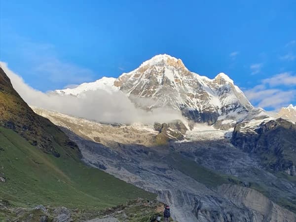
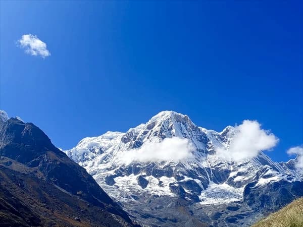
The Great Himalayan Amphitheatres: Annapurna’s Iconic Peaks & Views
Picture yourself inside a vast ring of mountains, shaped long ago by slow-moving ice. Welcome to the Annapurna Sanctuary. Turn any direction, sharp summits climb skyward, pressing close like towering figures frozen mid-step. Though still, they feel alive.
Not every path does this, but right here, the land rises up around you, walls of rock piling high, covered in frost and dark patches where light won’t reach.
Up front, the legends stand tall: Annapurna I to IV hold ground, followed by Annapurna South, Machhapuchhare, and Hiunchuli close beside it. Farther back, Dhaulagiri and Nilgiri lift themselves slowly.
Past these titans, frozen streams cling stubbornly to rock faces, the drop of Modi Khola cuts hard beneath, Kali Gandaki winds low and long.
That clash between sheer rock and silent green lands hard in your chest without warning. The strange thing is, standing there, you do not shrink in fear.
A quiet settles instead, as something deeper has gone still. People who live here treat the mountains as protectors.
Flora & Fauna of the Annapurna Himalayas
The flora and fauna of the Annapurna Himalayas are basically nature showing off. One footstep after another leads you across wild shifts in greenery, all held within the embrace of the Annapurna Conservation Area.
Each turn brings a new climate zone as if nature borrowed pieces from distant lands. Walking here feels less like hiking, more like drifting between worlds stitched together by trails.
Down by Pokhara, the land wears thick green robes with sal trees tangled with bamboo, banana plants, ferns, and orchids. Up above, cooler air brings a new cast: rhododendron blazing when spring hits, oaks standing quiet, maples flickering color, pines stitching the slopes together.
Up ahead, near spots such as Manang and the Upper Modi Valley, along rocky alpine edges, landscapes grow steeper, hushed. Here, juniper dots the slopes, twisted shrubs hold on, wild grasses weave through cracks.
Up ahead, beyond Thorong La, the sky presses lighter on Mustang. Breath comes shorter now. Close to the ground, moss spreads slowly over stone. Lichen holds tight to what little warmth remains in the rock.
If luck comes your way, hold quiet, stay unmoving, as a Himalayan tahr might appear. Blue sheep may follow close behind. Between boulders, musk deer leap without warning. On flat stones, marmots warm themselves in light.
Flying above, monals glide where thin winds part for them. Blood pheasants rise next. Griffons follow, their flight slow but sure across open skies. Also, Golden eagles claim the highest arcs.
This place? Among the richest trail habitats anywhere. Legs burn, sure, muscles ache with each step upward, yet sight after sight repays every breath spent climbing.
Jhinu Danda Hot Springs, Natural Healing after the Himalayan Journey
Jhinu Danda Hot Springs are basically the Annapurna region’s way of saying, “Good job, you survived, now sit down and soak.” Here, you will find water humming low beside mossy rocks. The air here sits softer than back up the hill.
Down past Jhinu village, beside the Modi Khola, warm springs wait after a steep drop on foot. Stone steps wind down, cutting through thick bamboo and leafy jungle growth.
The sound of rushing water arrives first, long before sight does. That noise stands out more when muscles ache from descending. Forest closes overhead, shading the trail just enough. Relief shows only once the steam rises into view.
Up from below, heated water surges through earth cracks into rocky basins next to an icy mountain stream. People here have soaked for ages, trusting the hot spring to loosen tight limbs after long walks uphill. The waters move slowly through stone, carrying what the mountains leach over centuries.
Here, fog lifts through crisp highland breeze, and trees stand close without sound. And if you are exploring further west, Beni Hot Springs offer a similar healing vibe near the Kali Gandaki. It is less famous, but just as legit.
Best Viewpoints While Trekking to Annapurna Himalayas Nepal
Poon Hill (3,210 Meters): The Classic Sunrise Viewpoint of Annapurna
Poon Hill is basically the Himalayas saying, “I got you.” It’s one of the most famousand most accessible viewpoints in Nepal, which means you get world-class mountain drama without signing up for extreme altitude suffering.
Situated high above Ghorepani, inside the Annapurna stretch, this familiar spot pulls in newcomers without fail. Even those certain they have witnessed every peak before find themselves pausing here.
Before sunrise, there is a walk up, thirty to sixty minutes through darkness. Light comes softly at first, then spreads fast across the rock faces. Gold seeps into ridgelines, followed by streaks of pink, flashes of orange. From this height, both Annapurna and Dhaulagiri show themselves in one long view.
A quiet hush hangs in the air, with views of Gurja Peak, Dhaulagiri I, II, III, IV, V, Tukuche peak, Dhumpus peak, Nilgiri, Annapurna I, Annapurna South, Hiunchuli, Gangapurna, Off to the side, Machhapuchhare cuts sharply with its fishtail shape, and Nilgiri Range threads through the middle ground.
Down below, rows of green slopes step down toward tiny towns fading into haze. Some early days bring thick cloud cover rising like a slow river beneath mountain tops. True, lots of people come when the trails are busiest.
Poon Hill grabs attention fast, and few spots here match its fame among Nepal’s mountain lookouts.
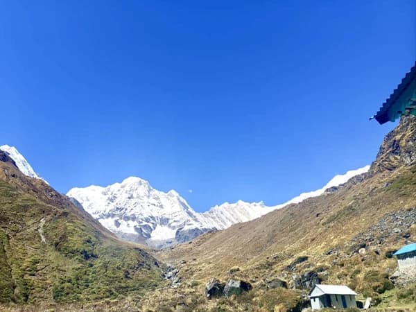
Annapurna Base Camp (4,130 Meters)
Up there, breath comes slow, 4,130 meters lifting feet into a stillness. Ice towers loom close now, stone ridges pressing in without leaving space.
Footfalls carry you through Modi Khola, beyond Bamboo, slipping past Deurali before reaching MBC-Machhapuchhare Base Camp. With each stride, every pebble underfoot, the slope tilts upward.
Out of nowhere, you stand inside a ring of giants, cradled by rock so high it feels like whispers between summits. Here at Annapurna Base Camp, distance fades, as peaks pull near.
High up, jagged edges slice through the air, which are impossible to overlook. Surrounding all sides, peaks rise: Annapurna I, then Annapurna South, Machhapuchhare with its pointed crest like a fin, followed by Hiunchuli, Annapurna III and IV, along with Gangapurna.
Also, glaciers hold ground in tight formation, circling without break. Morning arrives quietly, painting ice sheets gold, whereas evening pulls darkness down over frozen streams beneath.
This bowl of peaks holds more than rock and ice, as people say gods live among them. Machhapuchhare stands apart, never touched by climbers, its slopes thought to shelter Shiva himself. That belief changes how you walk, makes each step feel watched, softened.
Out here, away from the crowds, Annapurna Base Camp wraps around you like a quiet secret. The peaks rise close, with just raw rock and snow filling your eyes. Morning light spills slowly, painting glaciers gold, one of Nepal’s finest dawn shows.
Mardi Himal Viewpoint 4250m, and Base Camp (4,500 Meters)
Mardi Himal Viewpoint is where the Annapurna region quietly flexes. Floating above everything, the impact surprises you, stronger than promised. Perched along a narrow spine of rock instead of tucked into a bowl below, the spot breathes wild air, open sky, sharp edges.
High above the tree line, just off the Mardi Himal route Annapurna, this spot draws those chasing big mountain moments minus the crush of people. Reaching nearly 4,500 meters, you will find yourself staring straight up at Machhapuchhare’s sheer southern wall.
This is one of the closest non-technical mountain encounters in Nepal. Mighty peaks shoot skyward, including Machhapuchhare, Annapurna South, and Hiunchuli. On crisp mornings, Annapurna I shows its face, Gangapurna rises behind, and Annapurna III stands apart. These giants seem nearer now than they ever did at base camp.
Half the wonder happens while moving toward it. Through thick woods of rhododendron and oak, the path shifts without warning, into soft moss, then sudden clearings high above the tree line.
A sharp turn here reveals a slender spine of rock, edges falling steeply into silence below. Wind presses forward as distant peaks rise like stone giants beyond sight.
That Mardi Himal spot? It sticks around in your thoughts later, even if you barely mentioned it at first. Less famous, more intimate, and just a little bit badass.
Ghyaru & Ngawal Viewpoints: Hidden Gems Above Manang
Ghyaru and Ngawal are the kind of viewpoints you stumble into and then wonder why more people aren’t talking about them. Floating above the Marsyangdi Valley along the upper trail of the Annapurna Circuit, old stone villages rest near 3,670 meters. Views stretch wide without interruption. Fewer people pass through compared to lower trails.
Up ahead, Ghyaru and Ngawal spread out like a quiet stage above the world. From Upper Pisang, the path climbs hard with steady slopes. Still, every step finds its reward quickly.
Up there, Annapurna II, III, and IV rise like stone walls under open sky. Balcony views stretch wide, taking in Gangapurna, then Pisang Peak beyond. The valley below, Marsyangdi, cuts deep between ridges. Being so high puts you at eye level with peaks.
Over sunbaked ridges, the path winds through scattered prayer flags, patches of juniper, then tough mountain plants clinging on. There’s more silence, more wind, and way more time to actually look.
Here, Ngawal’s monastery adds a quiet spiritual weight to the view. Hidden gem status fully deserved.
Khopra Ridge (3,660 Meters)
A hill called Khopra Ridge waits where few go, even though it shows just as much of the high mountains. Up at 3,660 meters, it stands apart with open air and wide skies. This place belongs to those who would rather miss a crowd than chase one.
Out here, locals keep the path clear, giving it a quiet, timeless hiking feel. Standing high on a bare ridge changes everything; sightlines stretch farther and strike deeper. Not tucked in a bowl but out in the open, the land unfolds beyond what most trails offer.
From here, Dhaulagiri I rises into view, then Annapurna I appears beside it, followed by Annapurna South holding steady ahead. Nilgiri Himal catches the light next, while Tukuche Peak shows itself just behind, Dhampus Peak completing the ring around you.
Looking lower shifts something inside, a sudden pull as the Kali Gandaki Gorge reveals its depth below. High above, things strip down to bare rock and sky, with only scattered grasses breaking the silence of towering peaks.
Moving upward, trails pass through clusters of stone homes, where people offer quiet welcomes without needing words. Life here moves at its own pace.
Australian Camp & Dhampus: Easy Viewpoints Near Pokhara
Australian Camp and Dhampus are proof that you don’t need blisters, permits, or oxygen math to score proper Annapurna views. Perched between 2,000 and 2,400 meters, these gentle hill spots near Pokhara deliver striking sunrises and sunsets without long hikes.
Over Phewa Lake and across the Pokhara Valley, sightlines stretch without blockage. You will see Machapuchare stand bold, sharp like a blade against the sky. When morning clears, you will also see Annapurna South, Dhaulagiri, and Nilgiri.
What strikes most? How white peaks erupt suddenly from fields, trees, ordinary earth. Footsteps fall light on paths that wind through trees, stepped farms, open meadows, yet always follow old stone lanes between homes.
Life in Dhampus shows up in the daily routines of Gurung and Magar people. Farther along, a spot called Australian Camp came to be, thanks to travelers from down under who once passed through, leaving behind a name.
Cultural Mosaic of the Annapurna Region in Nepal
Gurung Villages of the Annapurna Foothills
Winding up through the lower edges of Annapurna, Gurung hamlets rest easy among green folds of hillside. Stone-built with slates darkened by rain and time, their homes stand sturdy beside paths worn smooth by passing feet. Ghandruk greets you first, then Landruk, followed by Sikles.
Prayer flags flutter above doorways where elders sit sipping tea before noon. You will also find villages such as Tangting and Bhujing.
Hailing from Nepal’s hills, the Gurung, often called Tamu, carry a quiet strength. Rooted in soil and season, they live close to nature through generations. Their tongue, Tamu Kyi, carries stories older than stone paths winding uphill.
Faith moves through them differently: part Buddhist chant, part temple offering, part whisper to mountain spirits at dawn.
Up on the slopes, terraced plots grow millet, barley, potatoes, along with whatever veggies suit the season. Goats and cows move freely, almost as if rules don’t apply where they step.
During festivals, men are dressed in bhangra outfits, kachhad wraps, topped with bold Gurung hats that stand out. Folks often wear a guniu cholo paired with patuka, along with striking jewelry. True enough, tales about grandfathers, uncles, or dads in Gurkha units get told with quiet pride at home.
Music spills out of village evenings where youth meet just like their grandparents did. Inside the Rodhi, laughter mixes with drumbeats under low wooden beams.
Festivals such as Tamu Lhosar bring village nights alive with drum echoes, meals steaming under open skies, and voices rising in old tales. Meanwhile, dances like Ghatu, Sorathi, and Chyau move through stories passed down generations.
Thakali Heritage of the Kali Gandaki Valley
High up in the Kali Gandaki Valley, Thakali traditions mix old trading routes with rich customs and meals that taste like history. Nestled between Annapurna and Dhaulagiri, their home, known as Thak Khola, follows the river through Mustang.
This group speaks a unique tongue, part of a lineage shaped by centuries in these high passes. Nestled within some of Earth’s most dramatic canyons are their homes: Tukuche, Marpha, Jomsom, Lete, Ghasa, plus smaller outposts close to Muktinath.
Though rooted in the Tibeto-Burman lineage, the Thakalis shaped life as quiet bridges linking Tibetan highlanders with southern valleys. Out here, long ago, Thakalis moved salt by caravan, back and forth across high passes into Tibet.
The land they come from? Called Thak-sat-soe, or Thak Khola, it holds steady through four core family lines: Chhyoki first, then Salki woven close, Dhimchen standing apart but linked, and Bhurki completing the shape.
Over in the hills, Thakali speaks through small voices, as Marphali, Panchgaunle, and Tin Gaule. You will find Buddhist chants mixed with Hindu rites, as well as echoes of old Bon beliefs and whispers of shaman ways. You will witness Toran Lha and Lhafewa.
Fine, start with flavor, Thakali cooking owns it. Their meals, often served on a single platter, pack sharp tastes without clutter, portioned just right. Across Nepal, people recognize that plate.
Then there is shelter: houses rise with slate walls and wooden frames, roofs laid flat against gusts.
Moving on, traditional dress like Labeda, Suruwal, Istakot for men and Jama, Cholo, Patuka, and Khasdo shawls for women adds quiet elegance to daily life.
Tibetan Buddhism along the High Annapurna Trails
Walking the tall paths near Annapurna, Tibetan Buddhism becomes part of each footfall. Through villages tucked in stone, belief shapes how people speak, cook, and rest.
Life in places such as Manang Valley carries a rhythm shaped by chants at dawn. Even on dusty tracks beneath Mustang's red cliffs, stillness hums behind every gesture. Across Thorong La’s edge, thin air holds echoes of mantras spoken for centuries.
From India, Vajrayana Buddhism moved into Tibet, carried by traders through high mountain paths. There, thought meets practice through rites, stillness, painted images, and hidden meanings woven tight.
Upward on the path, you will see carved mani stones whisper “Om Mani Padme Hum”. Prayer wheels turn slowly, set in motion by wind or a pilgrim’s hand moments ago.
In Manang, Braga Gompa holds time still with its presence. Elsewhere, small altars wait inside doorways with simple offerings tucked behind teacups and wooden beams.
Water drawn from the well comes after spinning a prayer wheel. Bowing happens just once before eating, brief but sure.
A quiet hum of chant often greets you inside a stone hut. Prayer wheels spin near backpacks leaning against pine beams, their sound mixing with the wind above the tree line.
Festivals of the Nepal's Annapurna Region
Lhosar: New Year of Himalayan Buddhist Communities
Lifting the spirit anew, that’s what it means for Gurung, Tamang, Sherpa, along with others woven into Himalayan life. Across Nepal and beyond, this moment takes root where high mountains meet quiet devotion.
Late December brings Tamu Lhosar for the Gurung people. When winter lingers, Sonam Lhosar arrives, celebrated by Tamangs in January or February. Come early spring, Sherpa and Tibetan communities mark Gyalpo Lhosar during February or March.
Early morning brings people to monasteries, where chants rise with smoke from butter lamps. Each flame burns away last year’s shadows, making space for luck ahead. The new zodiac animal steps in as old energies fade, guided by fluttering prayer flags lifted on mountain gusts.
Here, rooftop poles carry cloth whispers toward skyward winds, stitching hope into the high air. Folks fill village paths wearing old-style clothes, with men stepping lively in Bhangra outfits, Kachhad tied tight, while women glow in bright Gunyo Cholo, some draped in Ghalek instead.
Later on, prayer fades into dancing. Halls and open yards come alive with spinning dancers doing Ghatu and Chudka. Food spreads grow heavy with sel roti, tangy achhar, steaming chicken curry, and glasses of home-brewed liquor passed hand to hand.
Dashain: Nepal’s Biggest Festival
With a burst of color, noise, and laughter, Dashain takes hold across Nepal. Known widely as Vijaya Dashami, it shapes daily life for roughly fifteen days each year. Falling somewhere between September and October, the timing dances with moon phases.
The festival begins under the sign of Ashwin. It drifts forward until the night of KojagratPurnima. Locals pour out of cities when schools close, and workplaces quiet down.
Rooted in Hindu custom, sure, yet the whole nation treats it like a shared return. For those days, Nepal breathes differently.
Fresh after the monsoon, fields golden, people mark Dashain when Durga struck down Mahishasura. This time of year, brings more than myth; it gathers families around ripe crops, shared meals, moments that breathe thankfulness.
Barley sprouts take root at Ghatasthapana, marking the start. Momentum grows by Maha Ashtami, then carries into Navami. In villages, old customs sometimes include animal offerings.
That moment when feelings run highest? It’s Vijaya Dashami. Blessings come from older relatives as they place tika (rice, yogurt, red powder) and sprigs of jamara on your head.
Tihar: The Festival of Lights
Sparkling through late October into November, Tihar glows across Nepal like fireflies after rain. This five-day burst of brightness lands each year during Kartik. Though rooted in Hindu tradition, its pull stretches wide beyond any single path.
Strings of lamps climb walls were laughter spills from doorways. Music tumbles down alleys while homes wear garlands of marigolds. Flickering diyas dot the scene, bringing a touch of homegrown warmth. At every entrance, rangoli patterns sit freshly drawn.
One morning feels like this: Kaag Tihar gives praise to crows, believed to carry messages of fate. Next comes Kukur Tihar, when dogs get honored at last, a long-overdue nod to loyal companions. Cows take center stage later, alongside worship of the deity tied to abundance, during Gai Tihar and Laxmi Puja.
Oxen are lifted into light on Goru Tihar, also known as Govardhan Puja, a quiet tribute to steady strength. Then comes Bhai Tika, a day woven around siblings; sisters mark brothers’ foreheads with seven shades of tika (called saptarangi), offering words meant to guard life, and drape necks in flowers.
When Tihar arrives, children and young folks hop between homes. They perform songs with rhythm in their feet, moving door to door. Some carry drums; others clap loudly to keep time. They are later gifted with cash and snacks.
Required Permits for Annapurna Trekking
Permits in Nepal help shield delicate highland areas, plus they fund village projects. Trails stay passable because money goes toward upkeep, don’t assume goodwill skips paperwork.
If something goes wrong, officials need to track your location. Checkpoints pop up along routes. A friendly grin? Won’t cover your missing permit.
Most folks trekking here need the Annapurna Conservation Area Permit, called ACAP, a must-have that runs about 3,000 Nepali rupees, roughly 25 to 30 U.S. dollars. Covering every Annapurna route, it works for nearly every main trail in the region.
These days, wearing a TIMS CARD isn’t required by law in the Annapurna area, (but sometimes they required) yet certain guide services mention it anyway. It sits there like a spare key: optional, sure, yet handy when paths twist unexpectedly.
When your path crosses into delicate areas, getting a Restricted Area Permit could be necessary. Arranged only via an authorized trekking company based in Nepal, the process takes time. These regions often require extra paperwork just to enter. A local agency handles submissions on your behalf. Without their support, access gets blocked completely.
Trail guards check documents at set points, which means paper backups beat digital ones every time. A dead phone won’t help once you are on foot, so keep hard copies close. Same-day passes come from the Nepal Tourism Board offices, either in Kathmandu or over in Pokhara. Some travelers hand the task to their trekking company instead. Others prefer sorting permits themselves before leaving town.
Best Time to Trek the Annapurna Himalayas Nepal
Each season shapes the journey differently. Each turn through Annapurna shifts with the months, crisp air, clear peaks, mud underfoot, strangers on the path; it depends on when you go.
When spring arrives, from March through May, it becomes a top choice for walking the Annapurna trails. As blossoms burst across rhododendron woods, colors flood the hillsides, particularly near places such as Mardi Himal, Ghorepani and Ghandruk.
Warmth fills the daylight hours while nighttime begins letting go of its icy grip. Higher mountain crossings gradually shed their winter cover under these gentler conditions.
Later, clear skies follow the monsoon, which is why most people pick autumn, September through November. Trails stay firm underfoot after the rains stop. The Annapurnas stand out, so crisp they seem sharpened by hand. Light plays differently then, richer somehow.
Fresh mornings give way to gentle afternoons, while steady skies keep things predictable. For straightforward hikes beneath towering peaks, nothing beats this time of year.
Quiet trails wind through winter villages dusted in snow. Icy dawns greet early risers while afternoons fade fast into sharp cold. Higher paths often vanish under frost, sealed off by stubborn ice. This time of year, listen more closely to those who have walked long miles before.
As for monsoon, fog rolls in early when the rains start, sticking around through June to August, along with constant drizzle and sudden downpours. Lush valleys turn slick underfoot while waterfalls thunder nonstop beside mossy trails. Leeches show up too, uninvited yet common on damp forest paths.
Despite warnings, some regions stay mostly dry due to how the mountains block heavy showers. The upper Mustang hides behind peaks that keep storms at bay.
Bottom line? There’s no bad time to trek Annapurna, only different moods of magic.
Teahouse Accommodation & Trekking Experience
Up there, past the tree line, tea houses shift everything. Run by families whose rhythms match the trails, these small shelters do what only mountain homes can.
What stands out about trekking in Nepal is how it feels close, not like something handed out by a tour guide. Simple walls, simple space, that’s what the rooms offer, most times set up for two people. Two beds sit inside, each with a firm mattress, a pillow, and heavy quilts folded at the foot. Furniture shows up only where needed, nothing more.
Heat rarely reaches sleeping quarters, more so when climbing upward. Together with elevation, comfort tends to fade. A common eating space holds warmth, centered on one big stove. Private bedrooms might only appear in lowland settlements.
Western toilets sometimes come with them. Further up, people sleep together in open areas. Squatting latrines replace seated ones. This is simply how things work beyond the trees.
Facilities improve the lower you are and get more “adventurous” the higher you climb. Hot showers exist, usually for a small extra fee, but the phrase hot is flexible, especially on cloudy days when solar heaters do their best.
Charging phones, cameras, or power banks is possible in most tea houses, again for a small cost, and Wi-Fi pops up more often than you would expect (though it may move at mountain speed).
Annapurna Region Food & Local Cuisine
Food in the Annapurna region is a part of the trek’s personality. Most meals are cooked fresh in tea houses using local ingredients hauled in from nearby villages.
The most popular choice is Dal Bhat tarkari (plain rice, lentils, veggies, sharp pickles). Above that, you will also find momo, thukpa, noodles, chowmein, fermented greens, corn porridge, pancake, flat Tibetan loaves and many more.
Fresh mountain air brings plainer choices on the plate. Higher up, meals shift toward fewer ingredients done well. Down below, meat takes center stage more often than not. Dishes like pizza or pancakes show up unexpectedly, even here. Toast appears now and then, along with porridge, pasta, or a rare burger.
Up high, you will spot snacks such as chocolate, biscuits, dried fruit, nuts, or energy bars, but expect higher costs the further up you go. Also, local flavors like sel roti, yak butter tea, along with traditional Thakali and Gurung meals, shouldn’t be missed.
Some drinks just earn a spot all on their own. Black tea, milk tea, ginger, sometimes lemon, mint or that spiced kind called masala. Coffee warms hands too, along with thick hot chocolate.
Bottled sodas are also available, but are heavy on cost. Meanwhile, home brews such as fiery raksi, cloudy chhyang, and apple brandy can also be on the menu.
Boiled water from tea houses works best when you want something safe that also helps the planet. Bottled versions cost too much, plus they leave trash on paths where people hike. A filter tucked into your bag gives peace of mind if boiling isn’t possible. Purification tablets? They take up little space but do big jobs.
Annapurna Trekking Safety & Preparation
- Starting below the treeline and rising past 3800 meters, the Annapurna area shifts from warm lowlands to rugged snow zones; this means AMS doesn’t care how strong you are.
- Higher up, thin air hits everyone differently, fit or not. What feels manageable at first may shift without warning. Even those used to tough climbs can feel its effects.
- Slow climb with breaks helps the body adjust.
- A headache or feeling sick might show up first, with dizziness, and lack of hunger. You must pay attention when these appear together. Don’t brush off what your body signals. Ignoring them only slows things down.
- Some Annapurna trails feel steady; others push limits. Your legs need power, sure, but staying upright matters just as much. Workouts should mix steps that boost breathing control together with moves that firm the muscles used when stepping on uneven ground.
- Weather changes fast here and plans shift when danger shows up. Staying safe matters more than schedules.
- Bring just enough stuff, nothing more than you actually need. What fits matters less than what serves a purpose.
- Hiring a trained guide brings local knowledge, while porters assist with gear and route finding. Altitude checks happen regularly through their experience.
- Fresh morning steps beat shifting skies later. Dawn trails dodge wet surprises by noon.
- When you walk, stick to paths that have clear signs. Cutting across new routes is best left alone.
- Bottled water is fine if sealed properly. Water straight from the tap might carry risks unless it has been heated until bubbling or cleaned through a trusted filter.
- Fatigue slips in more easily when you are chilled, so staying dry helps hold it back. Warmth sticks around if clothes stay moisture free.
- Carry travel insurance covering high altitude treks and helicopter evacuations.
- Start by listing people to call if something goes wrong. Tell a friend where you plan to go.
Frequently Asked Questions
Where is the Annapurna Himalayas located in Nepal?
The Annapurna Himalayas are located in north-central Nepal, stretching from Besi Sahar to Manang, Mustang, and the Kali Gandaki Valley, within the Annapurna Conservation Area.
And from Pokhara to Ghorepani Poon Hill, ABC Base Camp, Mardi Himal, Australian Camp, Short Annapurna view etc.
What is trekking in the Annapurna Himalayas famous for?
Annapurna trekking is famous for diverse landscapes, tea house trekking, Gurung and Thakali cultures, Annapurna Base Camp, Thorong La Pass, and some of the best Himalayan viewpoints in Nepal. Like Poon Hill, Mardi Himal view point, Thorong La Pass.
What is the best time to trek the Annapurna Himalayas in Nepal?
Availabile all year but the best seasons are Spring (March to May) for rhododendron forests and clear views, and Autumn (September to November) for stable weather and sharp mountain scenery.
Is the Annapurna trekking suitable for beginners?
Yes. Treks like Poon Hill, Australian Camp, Short Annapurna view, Dhampus, and Mardi Himal are beginner-friendly, while Annapurna Circuit Thorong La Pass and Tilicho Lake are better for experienced trekkers.
What is the highest altitude reached in the Annapurna region?
The highest trekking point is Thorong La Pass (5,416 meters) on the Annapurna Circuit.
What is the Annapurna Base Camp altitude?
Annapurna Base Camp (ABC) lies at 4,130 meters, surrounded by Annapurna I, Machhapuchhare, Hiunchuli, and Annapurna South.
Is altitude sickness common in the Annapurna trekking?
Altitude sickness can occur above 3,000 meters, especially on the Annapurna Circuit and ABC trek.
Do I need a guide for trekking Annapurna Himalayas, Nepal?
While some routes can be done independently, trekking with a licensed local guide improves safety, navigation, cultural understanding, and overall experience with easy access.
What is Tilicho Lake, and can it be visited during Annapurna treks?
Tilicho Lake (4,919 meters) is one of the highest lakes in the world and can be added as a side trip on the Annapurna Circuit.
What wildlife can be seen in the Annapurna region?
Wildlife includes Himalayan tahr, musk deer, blue sheep, langur monkeys, Himalayan monal, and rare species like the snow leopard (very rare sightings).
Is the Annapurna trek safe?
Yes, Annapurna trekking is generally safe with proper preparation, weather awareness, insurance, and respect for altitude and local conditions.
What cultural experiences can I expect on Annapurna treks?
You will encounter Gurung, Thakali, and Tibetan-influenced communities, monasteries, prayer flags, mani walls, and festivals like Lhosar, Dashain, and Tihar.
Can Annapurna region trekking be done year-round?
Yes, but spring and autumn are ideal. Winter brings snow at high passes, and the monsoon brings rain in the lower regions.
Why is Annapurna considered one of the best trekking regions in the world?
The Annapurna region offers unmatched diversity, from jungles to glaciers, villages to high passes, combined with rich culture, accessibility, and legendary Himalayan scenery.